Showing posts with label Parying Indians. Show all posts

Saturday, July 23, 2011

Our river runs through the meadows

The Neponset River as it winds through
the Fowl Meadows circa 1890. (Courtesy of the Canton Historical Society)

At the edge of my property is a small stream, the Pequit Brook, and its source is the Reservoir Pond past Pequitside Farm. Living on a brook is an amenity that allows for plenty of opportunities to observe wildlife and the marking of seasons. Over time we have come to know the animals that inhabit our small corner of Canton. We have watched muskrats, ancient snapping turtles, the great blue heron, red-tailed hawks, numerous rabbits, fox, and all manner of mallards. The jewelweed and grass is abundant and the meadows are filled with red-winged blackbirds come fall. The winter gives way to woodpeckers and more flocks of waterfowl, even an occasional fisher cat and coyote. So abundant is the wildlife that at times we feel as though we live in a suburban wildlife preserve.

The Pequit Brook winds down through Sherman Street and eventually finds it way to the East Branch of the Neponset River. And the Neponset in turn finds its way to the Massachusetts Bay. Nobel laureate Hermann Hesse wrote: “How he loved this river, how it enchanted him, how grateful he was to it! In his heart he heard the newly awakened voice speak, and it said to him: Love this river, stay by it, learn from it. It seemed to him that whoever understood this river and its secrets, would understand much more, many secret, all secrets.”
So, what secrets does the Neponset River hold for us? To begin with, the name itself is somewhat of a secret. Of course it is an Indian name, and when the famous Algonquin scholar G. Hammond Trumbull was asked, he vainly endeavored to learn the significance of this name. “That word in all its forms of Naponset — Aponset, or Neponset defies analysis.” Many have surmised it means “river that flows through meadows.” This would be a fair description, since it travels through nearly seven miles of beautiful grassy meadows — the Fowl Meadows, in fact. So attractive to the early settlers were these grasses that the seeds were harvested and exported to Europe to produce the same luxurious grasses there.
Overall, the Neponset River travels more than 29 miles, starting at Gillette Stadium and ending near the gas tanks along the Southeast Expressway. The historical significance reaches back more than 10,000 years. Imagine the scene as Paleolithic man camps near the river right here in what would become Canton. Archeologists, both amateur and professional, have recovered over 2,600 Clovis spear points as well as mastodon tusks and caribou bones. The site, called Wamsutta, has been studied for more than 20 years. What were once the shores of a Pleistocene Lake seems to have been an important workshop of sorts where tools were made and wildlife harvested.
The recorded history of the Neponset starts around 1619, when Native Americans would use the river as a route to trade furs, largely muskrat and beaver. The wildlife was amazing. An apt description of what the Neponset River must have been like is found in a quote in a book written by Edward Johnson in 1628, entitled Wonder Working Providence: “The cod-fish, holybut and bass, do sport the rivers in, and alewives with their crowding sholes in every creek do swim.” The alewives in particular caused major legal battles in colonial Massachusetts, and the early records record heated arguments between mill owners who would dam and control the river and the fishermen whose livelihood was constantly in jeopardy as industry advanced. The argument to restore the fish and breach the dams still continues today.
The industrial growth as a result of this power source is nothing short of amazing. The second dam in the new world was constructed by Israel Stoughton, who was given permission to build a grist mill in what was known as Dorchester Plantation in 1634. What came next was a series of “firsts.” In 1640 shipbuilding began at what was known as Gulliver’s Creek (yes, there is a connection to Jonathan Swift’s Gulliver’s Travels). Soon sawmills, a snuff mill, powder mills, tanneries, slitting mills, and fulling mills began to rise near the banks of the Neponset.
Several of the most famous mills in America were started along the Neponset. In 1728, the first paper mill was erected. In 1765, Dr. James Baker founded a chocolate mill in Milton, which would become the world-famous Baker’s Chocolate Company. Closer to home, the Canton River, which fed the east branch of the Neponset, was home to James Beaumont’s Neponset Mills, where arguably the first piece of cotton cloth in America was made in 1802. In 1801, Paul Revere made his home here in Canton and erected his copper rolling mill (another first in the nation) along the tributary branch of the Neponset.
To get the best view of the Neponset River in Canton, take a drive down Dedham Street, and as you pass the old Cumberland Farm Complex take a left onto the property owned by George and Nancy Bates. The Bates still own a small portion, but the largest is now owned by the Trustees of Reservations (TTOR). When you come here you are visiting Signal Hill. This is perhaps an oft-overlooked location from where you can “overlook” the Neponset Valley. The hike is easy and the views are entirely rewarding. The boundary line between Canton and Norwood follows the center of the river.
In 2002, George and Nancy Bates sold the development rights of 135 acres of upland and swamp to the then MDC. Signal Hill is the result of a 111-acre gift given to TTOR in 2005 by the Bates. While it is called Signal Hill because it once held signals to assist in the navigation of planes to the Norwood Airport, it might have been more historically named.
Historically speaking, this area was generally known as Taunt’s Farm. At one time there were two prominent hills here, each about 120 feet high. Turtle Hill (now known as Signal Hill) and Pillion Hill, which was removed for fill used in Boston’s Back Bay. What is left, the single hill, affords an easily accessible view of Boston. The first settlers here were John and Hepsibah Taunt. Likely settled in 1758, this land was rich with nutrients and made the perfect home for this private in the Stoughton Militia. Three generations of Taunts would live on this land until around 1844. Eventually Elisha White would buy the property, and by the 1930s the land would become part of the land acquisition program for the Canton Airport.
Dredging of the Neponset River in Canton, 1913.
 (Photo by I. Chester Horton, courtesy of the Canton Historical Society)
The river we see today is not the same river that was used by the prehistoric or colonial people. In 1911, the legislature was pressed to act by allowing the dredging and straightening of the river. The Fowl Meadows had become “foul.” The stench and disease (most notably malaria) was dreadful. The legislature ordered the river to be repaired of these nuisances. The dredging operation began in 1913 and would widen and deepen the river. The refuse from the muck was merely deposited on the banks, and by 1923 complaints abounded from the landowners whose once fertile fields would now no longer drain properly. The straightening also bypassed the “horseshoe” curve in the river, which abutted Horseshoe Swamp. Even today the boundary line with Norwood follows the old course of the river and Horseshoe Meadow remains in Canton.
Dredging of the Neponset River in Canton, 1913.
(Photo by I. Chester Horton, courtesy of the Canton Historical Society)

In the 1960s the river was once again polluted and described as a “noxious mess.” A canoe trip in August 1966 from Canton was described in the Patriot Ledger as follows: “The moment we set our canoes into the putrid, murky water on Neponset Street we were overwhelmed by the noxious odor caused by the industrial waste dumped into the river by the various firms along its banks. Globs of sludge floated past us in the water.” So polluted was the trip that day, the canoes were forced to turn back — great globs of paper and raw sewage made the trip unbearable. This was a turning point for the Neponset. Once again the legislature took up the reclaiming of the Neponset River. In 1974, a bond bill was filed to begin the process of creating improvements to the damaged waterway.
Construction of the bridge over the
Neponset River to Norwood, April 1915.
(Courtesy of the Canton Historical Society)
At the lead of the conservation efforts was the Neponset Conservation Association. Founded in 1965, their mission continues today as the Neponset River Watershed Association. With over 700 members, hundreds of volunteers and a staff of three full-time and four part-time employees, this is the future of the Neponset River. For over 45 years this group has been responsible for raising the public awareness of our great river. The advocacy continues — just last week the legislature’s Environment Committee held a hearing on the Sustainable Water Resources Act. This act will hopefully set the process by which the Department of Environmental Protection, with the cooperation of the Department of Fish and Game, will set the definition for the amount of water that makes rivers sustainable.
In 2008 a member of the Massachusett-Ponkapoag Tribal Council testified at a public meeting organized to discuss the future of the Neponset River. I leave you with his sage words: “The Neponset people, and there were Neponset people, were forced to leave the Neponset River because those persons who came later decided there was a better use for the Neponset River than our use, which contributed to the well-being of our universe and yours for centuries. Now I’m going to speak for the elders — I’m going to speak for the finned, the furred, the winged, and the ancestors, mine and yours. These are the voices you are not listening to. Put the river back the way it was. Allow the herring to come back and sing their song.”


To visit Signal Hill, take Dedham Street and immediately after crossing I-95 and railroad bridges, take a left on University Road. Proceed through the office park. Parking is on the right just before the last building, also on the right. Free and open year-round, sunrise to sunset. Allow a minimum of one hour.




Monday, April 18, 2011

Balancing history at Pulpit Rock


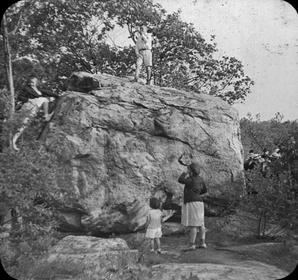
Balancing Rock, Canton, Massachusetts
(Courtesy of the Canton Historical Society)
By now you have no doubt created a short list of sites to visit in Canton that demonstrate some of the local curiosities of history and geology.  Many people have followed my recent columns and report trips to the Stone Bridge or the Indian Cave. This week we plan another “trespass” to our neighbors up on York Street.
A visit to Balancing Rock, also known as Pulpit Rock.
Photo by Eliot C. French, 1912.
(Courtesy of the Canton Historical Society)
By many names, the site is the same — Pulpit Rock, Balancing Rock, or Indian Council Rock. The subject of Indian lore, local history and today controversy, this site is among our most famous geological wonders. Located on a trail within 50 yards of the cul-de-sac at the end of Village Gate Road, the rock sits on a 60-acre parcel slated for development. Actually, not just sitting; balancing. The local developer plans to preserve the site with a small park and hopes that in doing so he will encourage the support of local opposition groups to the subsequent development of the remaining parcel. Rather than wade into the controversy, let’s focus on the rock.
Not to be taken for granite, um granted, Pulpit Rock is quite large, and was placed by the retreating glaciers atop bedrock that sits as a stone promontory 100 feet above hilly land and glacial till. The exact coordinates on the GPS place us at 71d26m W, 42d10m N. The land was part of the Colonial era site known as the “Great Sheep Pasture Lot.” But, in terms of time, the significance extends back to 14,000 years ago when the Neponset River Valley was formed by the waters of glacial melt. It may be hard to imagine today, but the Neponset River was more than a mile wide and swelled to a lake wider than five miles in the Neponset Basin.
Enormous significance is given to our area by professional and amateur archaeologists. Paleoamerican artifacts that date to 10,000-12,000 BP (years before the present) have been discovered in Canton, and in one site more than 2,600 tools and projectile points have been unearthed. Canton was rich in the tools and food needed by early man to survive in a hostile and harsh New England environment. There is little doubt that prehistoric man in New England called Canton home.
Pulpit Rock serves as a superb reminder of the people that inhabited this area thousands of years before the “contact period,” that time of European contact with native populations. There is, however, no person with greater curiosity in the history of this site than the owner and developer, Patrick Considine. Many stories abound as to the importance of Pulpit Rock, and recently new and exciting theories of use and significance have emerged.
To understand the new theories about Pulpit Rock you have to understand its owner, Pat Considine. Growing up on the family farm in North Clare, Ireland, Mr. Considine was familiar with ancient stone ring forts, dolmens and megaliths. As a boy he learned that “stone formations are an important part of the history of man.” And so when he began purchasing the land off York Street that contained Pulpit Rock, he was constantly trying to square off between folklore and history. Sometimes both are so intertwined it is impossible to separate the two.
Over the past five years as Mr. Considine amassed the 60-acre parcel, he was on a continuous path to learn more about Pulpit Rock. There is little written about this site. Some theories suggest that the Puritan missionary John Eliot used Pulpit Rock as his “pulpit” to preach his cross-cultural mission of converting the native population to Christianity. The area now known as Canton was once part of Eliot’s second so-called Praying Towns — a place where the Native Americans could live apart from the English and rule themselves as a Christian society. Eliot writes “though our poore Indians are much molested in most places in their meetings in way of civilities, yet the Lord hath put it into your hearts to suffer us to meet quietly at Ponkipog for which I thank God, and am thankful to yourself and all the good people of Dorchester.”
Katherine Sullivan, then president of the
Canton Historical Society,and Edward Bolster
 lead a visit to Balancing Rock in 1972.
 (Courtesy of the Canton Historical Society)
The Indians that settled on the 6,000 acres of the Ponkapoag Plantation certainly would have been familiar with Pulpit Rock. It is a commanding site across the land and a promontory from which folklore claims smoke signals could be seen in Sharon. But folklore was not enough for Mr. Considine, who felt the site had more significance than what had been handed down through local stories. He asked himself how he would “approach an investigation” that linked the site to pre-historic times — something that seemed elusive. On a beautiful autumn day Mr. Considine traveled to Exeter, New Hampshire and visited the New Hampshire Technical Institute and began researching standing stone sites in New England.
The seminal work on standing stones is titledManitou and tells the story of ancient Native American ritual sites across New England. The book was written by two established scientists who researched archaeoastronomy. This was the first book to examine a class of data that was ordinarily overlooked by prehistorians and is widely described as “a new research paradigm.” In Europe, especially Ireland and Britain, stone circles and megalith sites have been studied extensively for almost 50 years. In the United States, the SunWatch site near Dayton, Ohio, may date to the 1100s.
In December, Mr. Considine invited several individuals from the New England Antiquities Research Association (NEARA) to learn more about the prehistoric nature of Pulpit Rock. NEARA was founded in 1964 and has had plenty of experience supporting and debunking stone sites. Along on that day was Dr. Frederick Martin from Dedham. Dr. Martin is a research physicist who graduated from Yale and is active in the field of ion optics. Near the end of the day, almost as the group was leaving the site, Mr. Considine pointed out a row of stones ten feet from an ancient stone wall. These stones had been a curiosity to Mr. Considine, and the folks from NEARA became excited when they placed them in context with Pulpit Rock.
The row of stones, six feet in dimension, was aligned in the same direction and moved by humans. The second stone was what they termed a Manitou. Manitou is a word that is used by Algonquin speaking people to mean “spirit,” and these stones have been discovered across the New England landscape. The Manitou is similar in shape to a Colonial headstone and placed in places of great spiritual power. At Pulpit Rock the series of stones is aligned with magnetic north, and the theories that are emerging include the fact that this site may have been used to keep track of the passage of a year and possibly in connection with ceremony.
“There is a stone on which you can stand and see the Winter Solstice sun set over Pulpit Rock,” Dr. Martin said. “There is another stone that allows you to see the moon set at predictable intervals.” In essence, a straight line of monuments in which there are several unequivocal sightlines for annual and lunar timekeeping. A ceremonial stone clock, if you will allow the description.
What excites Mr. Considine is the fact that Pulpit Rock is quite similar and in his words “preeminent” to other sites with almost identical features. By mid-winter at the period of solstice late in the day, a deep shadow crosses the Manitou at Pulpit Rock and marks the darkest part of the year. Amazingly, the stones may line up to true north as it was over 10,000 years ago while today it sits off-axis by less than a few degrees.
Dr. Martin is working on publishing his findings in the journal Time and Mind, which specializes in archeoastronomy and prehistoric symbolic landscapes. He terms the site as fascinating and says that “since agriculture on bedrock is impossible, and colonial farmers are not known to be interested in the moon, it may be concluded that the stone row was constructed before the arrival of Europeans in New England.” The discovery in Canton is exhilarating in that it helps explain the long tradition of folklore and sacredness of a site long held so by modern people. The connections of Pulpit Rock to ancient people who were aligned by lunar and seasonal calendars is emerging as a very important reason for the site to be preserved.
This story originally appeared in the Canton Citizen on April 7, 2011.