Monday, April 18, 2011

Balancing history at Pulpit Rock


Balancing Rock, Canton, Massachusetts
(Courtesy of the Canton Historical Society)
By now you have no doubt created a short list of sites to visit in Canton that demonstrate some of the local curiosities of history and geology.  Many people have followed my recent columns and report trips to the Stone Bridge or the Indian Cave. This week we plan another “trespass” to our neighbors up on York Street.
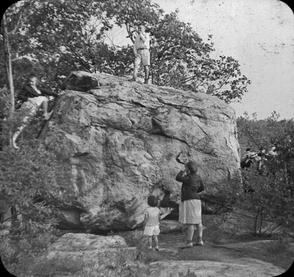
A visit to Balancing Rock, also known as Pulpit Rock.
Photo by Eliot C. French, 1912.
(Courtesy of the Canton Historical Society)
By many names, the site is the same — Pulpit Rock, Balancing Rock, or Indian Council Rock. The subject of Indian lore, local history and today controversy, this site is among our most famous geological wonders. Located on a trail within 50 yards of the cul-de-sac at the end of Village Gate Road, the rock sits on a 60-acre parcel slated for development. Actually, not just sitting; balancing. The local developer plans to preserve the site with a small park and hopes that in doing so he will encourage the support of local opposition groups to the subsequent development of the remaining parcel. Rather than wade into the controversy, let’s focus on the rock.
Not to be taken for granite, um granted, Pulpit Rock is quite large, and was placed by the retreating glaciers atop bedrock that sits as a stone promontory 100 feet above hilly land and glacial till. The exact coordinates on the GPS place us at 71d26m W, 42d10m N. The land was part of the Colonial era site known as the “Great Sheep Pasture Lot.” But, in terms of time, the significance extends back to 14,000 years ago when the Neponset River Valley was formed by the waters of glacial melt. It may be hard to imagine today, but the Neponset River was more than a mile wide and swelled to a lake wider than five miles in the Neponset Basin.
Enormous significance is given to our area by professional and amateur archaeologists. Paleoamerican artifacts that date to 10,000-12,000 BP (years before the present) have been discovered in Canton, and in one site more than 2,600 tools and projectile points have been unearthed. Canton was rich in the tools and food needed by early man to survive in a hostile and harsh New England environment. There is little doubt that prehistoric man in New England called Canton home.
Pulpit Rock serves as a superb reminder of the people that inhabited this area thousands of years before the “contact period,” that time of European contact with native populations. There is, however, no person with greater curiosity in the history of this site than the owner and developer, Patrick Considine. Many stories abound as to the importance of Pulpit Rock, and recently new and exciting theories of use and significance have emerged.
To understand the new theories about Pulpit Rock you have to understand its owner, Pat Considine. Growing up on the family farm in North Clare, Ireland, Mr. Considine was familiar with ancient stone ring forts, dolmens and megaliths. As a boy he learned that “stone formations are an important part of the history of man.” And so when he began purchasing the land off York Street that contained Pulpit Rock, he was constantly trying to square off between folklore and history. Sometimes both are so intertwined it is impossible to separate the two.
Over the past five years as Mr. Considine amassed the 60-acre parcel, he was on a continuous path to learn more about Pulpit Rock. There is little written about this site. Some theories suggest that the Puritan missionary John Eliot used Pulpit Rock as his “pulpit” to preach his cross-cultural mission of converting the native population to Christianity. The area now known as Canton was once part of Eliot’s second so-called Praying Towns — a place where the Native Americans could live apart from the English and rule themselves as a Christian society. Eliot writes “though our poore Indians are much molested in most places in their meetings in way of civilities, yet the Lord hath put it into your hearts to suffer us to meet quietly at Ponkipog for which I thank God, and am thankful to yourself and all the good people of Dorchester.”
Katherine Sullivan, then president of the
Canton Historical Society,and Edward Bolster
 lead a visit to Balancing Rock in 1972.
 (Courtesy of the Canton Historical Society)
The Indians that settled on the 6,000 acres of the Ponkapoag Plantation certainly would have been familiar with Pulpit Rock. It is a commanding site across the land and a promontory from which folklore claims smoke signals could be seen in Sharon. But folklore was not enough for Mr. Considine, who felt the site had more significance than what had been handed down through local stories. He asked himself how he would “approach an investigation” that linked the site to pre-historic times — something that seemed elusive. On a beautiful autumn day Mr. Considine traveled to Exeter, New Hampshire and visited the New Hampshire Technical Institute and began researching standing stone sites in New England.
The seminal work on standing stones is titledManitou and tells the story of ancient Native American ritual sites across New England. The book was written by two established scientists who researched archaeoastronomy. This was the first book to examine a class of data that was ordinarily overlooked by prehistorians and is widely described as “a new research paradigm.” In Europe, especially Ireland and Britain, stone circles and megalith sites have been studied extensively for almost 50 years. In the United States, the SunWatch site near Dayton, Ohio, may date to the 1100s.
In December, Mr. Considine invited several individuals from the New England Antiquities Research Association (NEARA) to learn more about the prehistoric nature of Pulpit Rock. NEARA was founded in 1964 and has had plenty of experience supporting and debunking stone sites. Along on that day was Dr. Frederick Martin from Dedham. Dr. Martin is a research physicist who graduated from Yale and is active in the field of ion optics. Near the end of the day, almost as the group was leaving the site, Mr. Considine pointed out a row of stones ten feet from an ancient stone wall. These stones had been a curiosity to Mr. Considine, and the folks from NEARA became excited when they placed them in context with Pulpit Rock.
The row of stones, six feet in dimension, was aligned in the same direction and moved by humans. The second stone was what they termed a Manitou. Manitou is a word that is used by Algonquin speaking people to mean “spirit,” and these stones have been discovered across the New England landscape. The Manitou is similar in shape to a Colonial headstone and placed in places of great spiritual power. At Pulpit Rock the series of stones is aligned with magnetic north, and the theories that are emerging include the fact that this site may have been used to keep track of the passage of a year and possibly in connection with ceremony.
“There is a stone on which you can stand and see the Winter Solstice sun set over Pulpit Rock,” Dr. Martin said. “There is another stone that allows you to see the moon set at predictable intervals.” In essence, a straight line of monuments in which there are several unequivocal sightlines for annual and lunar timekeeping. A ceremonial stone clock, if you will allow the description.
What excites Mr. Considine is the fact that Pulpit Rock is quite similar and in his words “preeminent” to other sites with almost identical features. By mid-winter at the period of solstice late in the day, a deep shadow crosses the Manitou at Pulpit Rock and marks the darkest part of the year. Amazingly, the stones may line up to true north as it was over 10,000 years ago while today it sits off-axis by less than a few degrees.
Dr. Martin is working on publishing his findings in the journal Time and Mind, which specializes in archeoastronomy and prehistoric symbolic landscapes. He terms the site as fascinating and says that “since agriculture on bedrock is impossible, and colonial farmers are not known to be interested in the moon, it may be concluded that the stone row was constructed before the arrival of Europeans in New England.” The discovery in Canton is exhilarating in that it helps explain the long tradition of folklore and sacredness of a site long held so by modern people. The connections of Pulpit Rock to ancient people who were aligned by lunar and seasonal calendars is emerging as a very important reason for the site to be preserved.
This story originally appeared in the Canton Citizen on April 7, 2011.

Sunday, March 27, 2011

The Fowl Meadows: For Peat's Sake


The Fowl Meadows at the Neponset River circa 1890.
(photo by L.C. Horton, courtesy of the Canton Historical Society)

There is an ancient map from 1794 inscribed with the names of the selectmen of Stoughton — Elijah Crane, Jabez Talbot and Nathan Crane — and on this map there are more than six bridges that cross the Neponset River in what is now Canton. Today, we mostly cross the Neponset River along Neponset Street, yet this road is among the newer roads, historically speaking. When we drive past the old Canton Airport, we see wetland and what we now consider “open space.” To the early settlers, this land was well supplied for access to food and valuable pastures.
The early bridges were used to access land in the Fowl Meadows, our western boundary. The first mention of this land dates to 1646, and much of this area was granted to Dedham in grants of 1653. As the train to Boston runs through these meadows, you can see luxurious grasses, and in late fall the meadows turn almost reddish in color. The grass here is actually called “fowl meadow” and is also known as “false redtop” (Poa serotina). This grass is typical of New England and “makes a soft and pliable hay, of excellent quality.” It could be mowed late in the season and made nutritious hay that was used as winter fodder.
The bridges that were used to access these meadows for grazing were named for the men who built them and owned grants to the meadows. Holmses Bridge, Thorp’s Bridge, Woodards Bridge, Fishers Bridge, and Majors Bridge — all ancient owners of meadows across the Neponset River. Vestiges of these structures are long lost. I know of a small arched double row of stones that is almost hidden by time and quite near the railroad tracks off University Avenue that I believe once played a part in the loading of carts filled with hay, but for the most part these crossings have been long lost.
What lies below the soft fields of grass is a thick, rich soil abundant with nutrients enriched by the river and thick with peat. After the retreat of the last ice age, the peat formed as the grasses decayed and were compressed by time. The peat is quite thick and Daniel Huntoon (History of Canton) observed, “Should our supply of coal ever become exhausted, fuel can here be obtained in an unlimited abundance.”
The peat is dense, and because of a lack of oxygen it inhibits the decay of archeological artifacts. In fact, some of the oldest artifacts in New England have been discovered along the Neponset River. Spots along the Fowl Meadows have served professional and amateur archeologists with a view that spans almost 18,000 years of human occupation. Amazing stories tied to the worksites, campsites, and migration of humans through this land will be shared in future articles.
The peat bogs gave rise to a little known and hardly mentioned industry in Canton. In 1908, J. Harry Hartley purchased 100 acres of land in Canton and Norwood. Hartley was the military editor of the Boston Globe and an esteemed member of the Ancient and Honorable Artillery Company of Massachusetts. This “newspaper man” had a vision that peat would become a new “cheap and inexhaustible fuel” for Boston.
Various attempts at harvesting peat had already been tried in New England. Peat, known as “bog fuel,” is the earliest stage of the creation of coal. The Boston and Maine Railroad tested this fuel in 1904. A large supply of peat was harvested in Lexington, and the railroad experimented over the winter of 1905 and found the fuel burned exceptionally well, but faster than coal. Also, in 1907, Mathew C. Sharpneck of Boston patented a new machine and assigned his patent to the American Peat Machinery Company of Portland, Maine. The machine used a series of blades to chop the peat and mix it such that it forms “ribbons of dark mud” that would be dried on a rack and cured with a current of air.
Hartley, the newspaper man, was well aware of the use of peat fuel in Europe and purchased one of Mr. Sharpneck’s machines. A plan was conceived along with Hartley’s son, Charles H. Hartley. Together these two men began the process of harvesting peat in the Fowl Meadows. In June 1908, all preparations were placed into operation. A small railroad track was laid deep into the Fowl Meadows and carts were connected via a steel cable to a series of sheds at the edge of the bog. A 100-foot-long building contained an engine house and the peat machine. Workers shoveled the heavy, wet peat into the hopper cars, and a winch pulled the cars along the rail to the main factory building. The contents were dumped onto a conveyor belt and processed through the peat machine. Drying sheds were also built on the property and the finished product was bagged for sale. This pioneering operation left little record. We would imagine that it soon thereafter failed, for no records exist that show otherwise.
The other reminder of the peat in the Fowl Meadows is the enormous fires that have historically consumed this land. Many times summer lightning storms would strike the ground, and the ensuing blaze would be all consuming. In 1923, a stubborn bog fire burned for several months. Norwood became “Smokytown” as the subterranean inferno blazed through the fall. This had been a year in which drought conditions had raised the alert to fire marshals throughout the commonwealth. More than 2,344 fires burned over 46,646 acres of fields and woodland, causing extensive damage.
In Canton, the summer of 1923 was particularly bad, and by all accounts the worst that had been seen in more than 40 years. Several tons of hay owned by Elijah White was destroyed in mid October by a fire that was set by two boys. That same day three tons of hay was burnt at William Murphy’s house on Bailey Street. In one day alone, fires were reported on Everett, Turnpike, Pecunit and Walpole streets, as well as Spring Lane and six other locations. In all, more than 13 fires burned on Friday, October 12, 1923. This set a record for the most working fires in one day in the Canton Fire Department’s history.
The bog fires burned for nine weeks. The smoke was excessive and more than 1,700 acres were ablaze through 1923. Hiking deep into the underbrush, firemen cut a four-mile-long ditch through the meadows and kept water pumping through the cut to create a fire line. The fire burned five to six feet underground, fueled by the never-ending supply of peat. Firemen on horseback worked their way into the deepest reaches of the meadows to access the edges of the fire and reported hellish scenes where the fire undercut root systems such that trees would collapse. “Through the smoke wreaths the bare branches of the trees showed gaunt and spectral … tongues of yellow flames were burning briskly amidst the tangle … rain was ineffective, breathing was difficult, eyes smarted and shed involuntary tears, and the heat of the ground felt hot through the sole of one’s boots.” The smoke from these fires caused such darkness that auto accidents became commonplace. After nightfall, travel became treacherous; you “literally could not see your hand in front of your face.”
The fires, although less frequent, are still a problem today. If you talk with Jim Fitzpatrick, our former fire chief, he can tell many stories of the meadow fires that were started by lighting or train sparks or errant cigarettes thrown from moving cars. More than 170 brush burn permits have been issued this year, so as you smell the wafting smoke from the spring burning season, recall the stories of the great fires in the Fowl Meadows and think about our history for peat’s sake.
This story ran in the Canton Citizen on March 24, 2011

Sunday, March 13, 2011

A Ring of the Son of Thunder

Memento Mori ring cast as a memorial to
Rev. Samuel Dunbar, 1783. (Courtesy of Eldred’s Auction)
The simple inscription on the inside of a small gold ring tells an amazing story that reaches back over 300 years to the birth of Samuel Dunbar. The inside of the ring in a colonial script reads: “Rev’d Saml. Dunbar June 15, 1783 AE 78” and a makers mark “PR.”


For all purposes, know that when I write of Canton, I write of the place that began as Dorchester, became Stoughton, was divided into parishes, and ultimately became what we know as Canton in 1797.


A receipt from 1777 signed by Samuel Dunbar
in the collection of the Canton Historical Society
As this town grew, the need for ministerial guidance was at the forefront of this community. The town minister was as important, and perhaps even of greater importance as that of the town doctor or miller. Samuel Dunbar was born in Boston on October 2, 1704, and when he was 4, his father died. At a very early age he attracted the attention of the Reverend Cotton Mather. Mather held the strictest of religious doctrines, best exhibited by his views on witchcraft and the subsequent hangings at Salem. Under Mather’s guidance, Dunbar attended Boston Latin School and Harvard College. By 1727, the people of Canton reached out and sent letters of inquiry asking that the 23 year old accept a ministry over the Church of Christ in Stoughton.


Through the years in Canton, a handsome house was built on what is now Chapman Street. A family grew and the reverend became extremely influential in all things religious and politic. The image of the man in a “long black gown, his snow white bands, his flowing gray wig, his black short-clothes, his knee and shoe buckles” stir a very proper picture of a righteous man. Upon the death of a resident who had not been an attendant at church, Dunbar stood at the head of the coffin and turned to the surviving relatives and proclaimed that “his body was before them, but his soul was in hell.”


In his early ministry in Canton he was a staunch supporter of the Crown, as all were in the middle of the 18th century. Dunbar was of the highest moral character and most esteemed by the entire community. When the call of duty was made by the king in 1755, Dunbar, as chaplain, accompanied Richard Gridley and Paul Revere (then 21) to fight against the French at Crown Point.


The Doty Tavern depicted in an 1876
drawing for Potter’s American
Magazine (Courtesy of the Canton Historical Society)
Over the years, as discontent grew among the people of the colonies, the fiery reverend changed sides and vociferously supported the patriots’ cause. In fact, in 1774 Dunbar bore witness to the birth of liberty. On Tuesday, August 16, 1774, delegates from around the surrounding towns gathered at Doty Tavern, at the foot of the Blue Hill, to hold a “Congress.” This meeting would bring about the emancipation from the tyrannous hands of the king. What would become known as the Suffolk Resolves was first discussed at this meeting. Dunbar, against the advice of family, friends and fellow ministers, attended the meeting and opened with a prayer that was described as “the most extraordinary liberty prayer” ever heard. It would not be hard to imagine coming from a person who once prayed that God would “put a bit in their mouths and jerk them about, send a strong northeast gale, and dash them [the British fleet] to pieces on Cohasset Rock.”


Dunbar was an amazing man, and in the truest sense a patriot, alongside Adams, Hancock, Revere, and Warren. He was known alternatively as a “Son of Thunder” and a “Son of Consolation.” As the “eldest Son of Liberty,” Dunbar bore witness to an extraordinary time in our history, giving comfort during times of distress and thanks during times of triumph. Samuel Dunbar lived long enough to see victory and the birth of our nation.


The first minister to publicly read the Declaration of Independence from the pulpit died on June 15, 1783. It would take 13 days for the great man to die, in excruciating pain, yet surrounded by family and friends at his home in the Old Parsonage. Huntoon describes the scene: “As the shades of evening approached, his pulse became slower and his breath shorter…” An affectionate friend kneels and inquires upon the old man’s pain, to which the response is, “I have served a good Master, and he has not forsaken me.”


Samuel Dunbar’s Parsonage which once
stood on Chapman Street. (Courtesy of the
Canton Historical Society)
Dunbar’s obituary ran in the Independent Chronicle and the Universal Advertiser on July 3, 1783. “They gather’d together, and with a generofity and tendernefs chearfully agreed to inter him at their common expence” continuing “the congregation, form’d in two ranks, proceeded from the dwelling houfe of the deceafed firft, the church next, then the deceafed borne by twelve principal men of the parifh, and the pall fupported by eight of the neighboring minifters.” Once committed to the grave, the obituary concluded, “The sweet remembrance of the just, Shall flourish when he sleeps in dust.”


And now to the ring. A recent caller from Cape Cod inquired as to what I knew of Dunbar, all of which I have related in this story. The initials “PR” intrigued me. Could this be … Paul Revere? In fact, this gold ring was most likely cast by the hands of the patriot and friend of Dunbar. As was the custom for the wealthy, a provision was made to quickly gather up gold and silver and have it cast into rings as a Memento Mori. These rings would be given as gifts to those closest friends as a way of signifying the importance of the man and as a literal reminder that you too shall “remember your mortality.”


A call to my friend, Nina Zannieri, the executive director of the Paul Revere House, confirmed, “It looks pretty good to us.” But, how does “pretty good” stack up? Digging further we found that in 1783 Paul Revere wrote in his day book that he cast eight rings for a single client, Capt. James Indicot. Zannieri writes, “It seems unlikely that is related to the one in your picture.”


What Zannieri did not immediately connect was the fact that Indicot was actually James Endicott — of Canton. James Endicott served as a captain in the Revolution at Lexington, Dorchester Heights, Cambridge, and Ticonderoga. Endicott was a friend of Revere; in fact, when Endicott’s house burned to the ground in 1806, it was Paul Revere who led the public financial campaign to rebuild the house against the impending winter. The brick house still stands on Washington Street, just past the high school.


Endicott, at 44 years old, was a rising and prominent citizen. A representative to the General Court, justice of the peace appointed by John Hancock, member of the committee that separated Canton from Stoughton, and the town treasurer, it was Endicott that placed an order for eight gold rings with Paul Revere. The daybook entry is made after May but before July 1783, and reads, in part, “to 8 Gold morn’g ring, weight 15.8 – 4 pounds, 4 shilling, 4 pence. Making ——- 1 pound, 6 shilling, 8 pence – Paid.” So, eight rings were cast about the same time as the death of Samuel Dunbar; one has survived.


On April 9 at Eldred’s Auction Gallery in East Dennis, we will see Paul Revere’s memorial gold ring cast for our second minister, Samuel Dunbar, hit the auction block. Presale estimates for this piece of our town’s history are between $4,000 and $8,000. History is alive and well — but at the right price.